Power of Web-GIS for Strategic Decision-Making

The incorporation of location-specific data into business processes is on the rise, playing a crucial role in enhancing operational efficiencies and boosting profitability. From customer demographics and product shipment tracking to real-time asset monitoring, location-based insights have become key elements in modern business planning and strategy.
Concurrently, the usage of Geographic Information Systems (GIS) for tasks such as mapping, data visualization, and analysis has grown significantly across various sectors. GIS, with its capacity to represent and scrutinize spatial data, is now a vital tool for deriving profound insights, refining strategic planning, and enabling more informed decision-making.
Exploring the World of Web-GIS
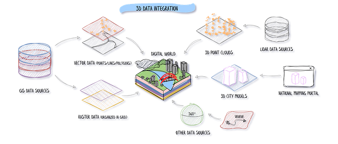
Web-GIS is a digital system that provides users with the ability to access, visualize, interpret, and analyze geographical data interactively and dynamically over the internet. This online system enhances the traditional GIS functionalities, making geographic data interactions more smooth and seamless.
The core role of Web-GIS is to promote the integration, storage, analysis, and presentation of geospatial data on the web. It utilizes internet connectivity to foster a collaborative platform for sharing geospatial information, thereby broadening its accessibility.
Web-GIS finds utility in a wide array of applications, providing visual insights into geographical data and aiding decision-making across various sectors. It serves as a valuable tool for businesses, government entities, researchers, and the public to access and understand intricate geographical data in an easy-to-use format.
Ranging from tracking real-time data such as traffic and weather patterns to mapping environmental shifts, managing natural resources, and planning urban development, Web-GIS offers a comprehensive platform to visualize and understand geospatial relationships and patterns.
Real-World Applications of Web-GIS
Google Maps is a classic example of a Web-GIS application, enabling users to interact with diverse geospatial data such as locations, routes, and traffic information. It provides real-time updates and equips users with interactive tools for exploring geographical information.
Below are a few ways in which Web-GIS has been put to use across different sectors, showcasing its versatility:
- City Planning: Urban development professionals leverage Web-GIS to visualize urban expansion, assess infrastructure needs, and understand environmental impacts. It fosters public participation and facilitates more sustainable urban planning.
- Real Estate: Property platforms utilize Web-GIS to offer interactive maps and location-specific information to prospective buyers, facilitating a comprehensive property exploration experience.
- Conservation Efforts: Conservationists employ Web-GIS to keep track of wildlife habitats, monitor endangered species, and measure the effects of human activities on nature.
- Transport and Logistics: Businesses use Web-GIS to streamline delivery routes, monitor vehicles in real-time, and enhance fleet management.
- Public Health: During the COVID-19 pandemic, public health organizations used Web-GIS extensively to track disease spread and plan interventions.
- Tourism: Travel platforms use Web-GIS to offer tourists interactive maps and location-based services, enabling users to plan their routes and find local attractions.
- Disaster Management: Authorities use Web-GIS for predicting, preparing for, and responding to natural disasters, ensuring effective resource allocation and public communication.
- Retail: Retailers leverage Web-GIS to analyze customer behavior, identify potential store locations, and devise targeted marketing strategies.
Synergy of Web-GIS and API Development
API development, when synergized with Web-GIS, can greatly enhance the functionality and user experience. APIs act as connectors, enabling Web-GIS to integrate smoothly with other systems and software, expanding its utility.
APIs facilitate data exchange between various platforms and the Web-GIS application. They can draw real-time data from different sources, enabling dynamic updates within the Web-GIS environment. This could range from live traffic updates to real-time asset or delivery tracking.
The amalgamation of Web-GIS and API development can revolutionize numerous sectors by offering real-time, interactive data visualization. Below outlines a powerful combination can transform two industries: delivery services and real estate:
- Delivery Service: APIs can feed real-time data about each delivery vehicle’s location into the Web-GIS system, which then visually represents each vehicle on a map. This real-time data can be used to optimize delivery routes.
- Real Estate: APIs can pull data from real estate databases, updating property listings in real time. The visual capabilities of Web-GIS allow users to explore available properties on a map and filter properties based on their preferences.
The combination of Web-GIS and API development offers dynamic, interactive, and data-rich applications. It allows real-time data visualization, greater user interactivity, and more efficient data management.
Web-GIS as a Tool for Web Developers
Incorporating Web-GIS into web development opens new doors for creating interactive and dynamic applications. It brings geospatial data to the fingertips of users, offering valuable insights and enhancing decision-making capabilities.
Web-GIS is not just a useful tool in the web developer’s toolkit — it’s a game-changer. Its capabilities can transform your web applications, making them more dynamic, interactive, and valuable to users.
Web-GIS equips users to make real-time decisions based on geospatial data. This can aid businesses in identifying new store locations, optimizing delivery routes, or targeting marketing efforts. For consumers, it could help in choosing the fastest route or finding a new home. By offering dynamic, real-time insights, Web-GIS is transforming how we interact with and understand the world around us.
— -
At e-dimensionz Inc, we harness the power of Web-GIS and API development to craft solutions tailored to specific business needs. For instance, integrating Web-GIS into an e-commerce platform can help customers locate physical stores, track deliveries in real-time, or visualize demographic data for targeted marketing.


